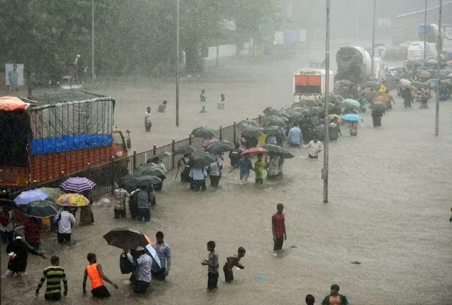
As monsoon rains drench Mumbai every year, the city turns into a waterlogged mess, with streets submerged, local trains stalling, and life grinding to a halt. For Mumbaikars, the arrival of June means only one question prevails: “Will my home flood first or my office?” This flood phenomenon is so predictable that it mirrors the uninvited visits of distant relatives who come, wreak havoc, and announce a return. Despite the city’s wealth and reputation as the financial capital of India, flooding disrupts Mumbai every monsoon cycle, causing widespread distress.
The Economic and Human Toll of Flooding
The financial damage caused by Mumbai’s floods is staggering. The city suffers an estimated daily loss of ₹400 crore during heavy rains. The impact is felt most harshly by daily wage workers and small businesses who face income disruption and hardship. Beyond economics, flooding has severe health consequences, with waterborne diseases such as dengue and leptospirosis becoming prevalent because of stagnant water and sewage overflow. Sadly, every year many succumb to illness triggered or worsened by flood conditions.
Why Does Mumbai Flood Every Year? Key Reasons Explained
1. Geographic and Historical Background
Mumbai was not always the bustling metropolis it is today. Originally, it consisted of seven small islands — Bombay, Mazagaon, Parel, Worli, Mahim, Little Colaba, and Old Woman’s Island (Colaba). These islands were separated by water and connected only by boats or land when tides were low.
The transformation into a single landmass was orchestrated by the British East India Company through extensive land reclamation starting in the late 17th century and continuing over 150 years. This “landfill” turned the original seven islands into the city we now know as Mumbai. However, this reclaimed land is ironically at or below sea level in many places, making it naturally prone to waterlogging and flooding during heavy rain or high tides.
2. Outdated Drainage Infrastructure
Mumbai’s drainage infrastructure, largely built by the British over a century ago, was designed to handle only around 25mm of rain per hour. Today, monsoon rains can produce up to 100-150mm of rainfall per hour in some areas — far exceeding the capacity of the century-old system. The gap between drainage capacity and actual rainfall volume is a fundamental reason why water accumulates and flooding happens.
Additionally, approximately 80% of Mumbai’s drainage system is open channels rather than closed piping, leading to frequent blockages. Citizens often dispose of plastic bottles, food wrappers, and household waste directly into these drains. This garbage clogs the drains, impeding water flow and intensifying flooding.

3. Combined Sewage and Rainwater Systems
A critical and dangerous aspect of Mumbai’s drainage design is the combined handling of both sewage and rainwater in the same drains. During heavy rains, the system gets overloaded and chokes, causing not just rainwater but also sewage to overflow onto streets. This mixing pollutes surfaces and spreads disease, compounding the public health risk during floods.
4. Impact of Coastal Location and High Tides
Mumbai is a coastal city with drainage systems designed to discharge water into the sea. However, during high tide, seawater pushes back into the drainage outlets, causing the BMC (Brihanmumbai Municipal Corporation) to close the drainage gates to prevent seawater ingress. This preventive measure, while protecting against seawater flooding, ironically blocks rainwater drainage completely, leading to urban flooding, especially in low-lying artificial localities like Dadar, Sion, Matunga, Kurla, King’s Circle, and Chembur.
Urbanization and Its Effect on Natural Drainage
Another key contributor to Mumbai’s flood problem is rapid, unplanned urbanization. Areas that used to be natural wetlands, mangroves, and open land capable of absorbing rainwater are now fully developed with skyscrapers, malls, roads, and commercial complexes. For example, neighborhoods such as Dadar, Sion, Wadala, and Bandra-Kurla Complex have been built over reclaimed land that historically served as natural water sinks.
With the disappearance of natural absorption zones, the rainwater has nowhere to percolate into the ground, exacerbating overflow and flooding. This urban expansion, without adequate ecological consideration, has turned water retention natural grounds into impermeable concrete surfaces, pushing more water onto roads and drains.
The Political and Administrative Neglect
Despite the clear and recurring problem of flooding, political and administrative efforts have been insufficient and piecemeal. There seems to be a disconnect between the scale of the problem and the urgency of the responses. The prevailing attitude among politicians appears to be complacency, possibly owing in part to the legacy idea that the British-built drainage system was permanent and adequate—an assumption long invalidated by demographic and climate changes.
Memes and social media posts capture the public frustration and irony of the situation, but lasting solutions require concerted administrative will, funding, and strategic planning rather than humor alone.
What Can Be Done? Potential Solutions
Addressing Mumbai’s flooding requires a multi-pronged approach combining infrastructure upgrades, waste management reform, urban planning adjustments, and climatic adaptation:
- Overhaul and Modernize Drainage Systems: The existing drainage infrastructure must be extensively upgraded to handle increased rainfall volumes. This includes expanding pipe capacities and converting open drains into closed conduits to prevent blockages.
- Separate Sewage and Rainwater Systems: Dividing sewage and rainwater drainage systems would prevent sewage overflow during heavy rains and reduce health hazards.
- Improved Solid Waste Management: Strict enforcement against dumping garbage in drains is crucial. Public awareness campaigns and regular cleaning drives must be institutionalized.
- Preservation and Restoration of Natural Absorption Areas: Where feasible, restoring mangroves, wetlands, and open grounds can help absorb flood waters naturally.
- Engineering Solutions for High Tide Issues: Technologies that allow drainage even during high tide, such as pumping stations or tide gates that don’t block outflow, should be explored.
- Urban Planning with Climate Resilience: Future urban development must consider flood risk, maintaining green zones, permeable surfaces, and proper elevation planning to mitigate waterlogging.
- Government Accountability and Transparent Policies: Authorities need to acknowledge the scale of the problem openly, release data, involve citizens and experts in planning, and avoid bureaucratic inertia.
Final Thoughts
Mumbai’s flooding is not simply a monsoon nuisance but a multifaceted crisis shaped by geography, colonial history, infrastructure neglect, urbanization pressures, and governance challenges. Understanding these interconnected facets is crucial for devising effective, lasting solutions.
Mumbai, as India’s financial powerhouse, deserves a resilient and adaptive urban system capable of withstanding the intensifying impacts of climate change. Through strategic policy reforms, civic engagement, and infrastructural investments, it is possible to reduce the annual flood disruptions that have held back the city’s growth and the well-being of its inhabitants for decades.